Desert Canyons and Alpine Summits
Explore the wonders of California’s eastern side—the world’s oldest trees, Death Valley National Park, and the alpine wonderland of Mammoth Lakes, starting and ending in Bishop.

Trip Itinerary Overview
9 stops on this route

Stop 1
Bishop
Stop 2
Big Pine
Stop 3
Independence
Stop 4
Lone Pine
Stop 5
Stovepipe Wells
Stop 6
Furnace Creek
Stop 7
Ancient Bristlecone Pine Forest
Stop 8
Convict Lake
Stop 9
Mammoth Lakes
Car & RV Rentals
Trusted car & RV rental companies make your trip much easier


Discover More of California
Stop 1: Bishop
Roll out of Bishop Airport and get ready for outdoor adventure. This eastern Sierra hub lies at the intersection of arid desert and alpine mountains, where sagebrush plains are framed by chiseled summits. Take a hike in the John Muir Wilderness. Go mountain biking in the Owens Valley. Go rock climbing in the Buttermilks, or boating or fishing at Lake Sabrina. Or just hang out in town and taste what Bishop locals are making: elk and buffalo jerky at Mahogany Smoked Meats, freshly baked bread at Erick Schat’s Bakkery, and artisan spirits at Owens Valley Distilling Company.
Planning Resources
- John Muir Wilderness – https://www.fs.usda.gov/recarea/inyo/recarea/?recid=21875
- Visit Bishop – http://www.bishopvisitor.com
- Lake Sabrina Hiking – https://www.bishopvisitor.com/lake-sabrina-hiking/
Stop 2: Big Pine
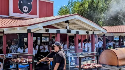
Flanked between the eastern Sierra Nevada and the White Mountains, Big Pine is U.S. 395’s gateway to outdoor paradise and mouthwatering barbecue. Drive up Big Pine Creek Canyon and hike along the stream near Big Pine Campground, then head back into town and refuel at Copper Top Barbecue. Order tri-tips, ribs, chicken, or pulled pork at the window, then stake your claim on a picnic bench and admire the turrets and towers of the Palisades crest.
Planning Resources
- Inyo County – Big Pine – https://inyocountyvisitor.com/bigpine/
- Scenic 395 – https://www.scenic395.com
Stop 3: Independence
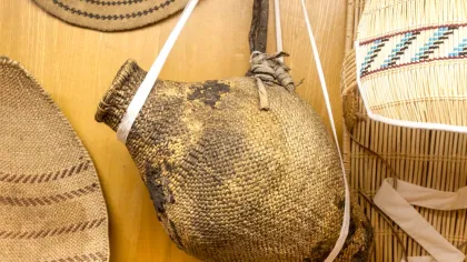
This tiny town boasts one of the best collections of history buildings on U.S. 395, including the 1927 Inyo County Courthouse. Just three blocks west, the Eastern California Museum houses a diverse collection of artifacts that document the Owens Valley’s history, including Native American baskets, preserved birds’ eggs, and a restored steam locomotive. The coolest spot in town is Eastern Sierra Ice Cream Company, where you’ll be tempted by creamy, creative flavors. (Ed. note: As of Jan. 2025, Eastern Sierra Ice Cream Company is temporarily closed. It is slated to reopen in the spring.)
Planning Resources
- Eastern California Museum – https://www.inyocounty.us/residents/things-to-do/eastern-california-museum
- Inyo County Tourism – https://inyocountyvisitor.com/
Stop 4: Lone Pine
This town is the jumping-off point for hikers tackling Mount Whitney, the tallest summit in the lower 48 states (14,505 feet). But you don’t need to conquer the peak to be wowed by Lone Pine‘s vistas—there’s plenty to see from your car seat. Stop in at the Whitney Portal Store and Hostel to pick up souvenirs, or hike the Whitney Portal National Recreation Trail. Just south of Lone Pine, check out the costumes, saddles, and prop guns at the Museum of Lone Pine Film History. Pick up the Movie Road Self-Guided Tour booklet and drive the Movie Road to Movie Flat, where dirt roads and trails fan out to famous film locations like Gene Autry Rock, Lone Ranger Canyon, and Gary Cooper Rock.
Planning Resources
- Mount Whitney – https://www.nps.gov/seki/planyourvisit/whitney.htm
- Whitney Portal – https://www.alltrails.com/trail/us/california/mount-whitney-portal-to-lone-pine-lake
- Lone Pine Chamber of Commerce – http://lonepinechamber.org/
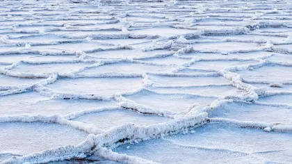
Stop 5: Stovepipe Wells
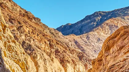
For travelers entering Death Valley National Park from U.S. 395 and the west, Stovepipe Wells offers food, lodging, and trailheads for short, spectacular hikes. Stroll through Mosaic Canyon, where eons of time and countless flash floods have decorated the walls with shiny marble mosaics. Take a walk through the colorful corridor of Golden Canyon, where an ancient lakebed has morphed into sandstone badlands. Explore the 90-foot-high Mesquite Flat Sand Dunes, shimmering mountains of sand graced by dramatic shadows at sunrise and sunset. After a full day of exploring Death Valley, slake your thirst at the Badwater Saloon.
Planning Resources
- Stovepipe Wells – https://www.nps.gov/places/stovepipe-wells-village.htm
- Golden Canyon – https://www.nps.gov/deva/planyourvisit/golden-canyon.htm
- Death Valley National Park – https://www.nps.gov/deva/index.htm
- Mosaic Canyon – http://www.nps.gov/deva/planyourvisit/mosaic-canyon.htm
Stop 6: Furnace Creek
Furnace Creek is Death Valley‘s main visitor services area, with restaurants, campgrounds, lodgings at the Oasis at Death Valley, and the world’s lowest-elevation golf course (214 feet below sea level). Within a short drive are some of the park’s premier attractions, including Badwater Basin, the lowest point in the western hemisphere, tipping the altimeter at 282 feet below sea level. This surreal tract of crunchy salt crystals is the remains of a 600-foot-deep lake that dried up eons ago. Artists Drive offers a slow 9-mile drive past the colorful hues of the Amaragosa Range’s sedimentary hills. (Time your trip for late afternoon, when the multi-colored cliffs—pink, mauve, gold, green, lavender—are at their most vivid.) At sunset, sip a cocktail at the Inn at Death Valley, and make plans to stay up late and gaze at a black-velvet sky filled with stars.
Planning Resources
- Badwater Basin – https://www.nps.gov/places/badwater-basin.htm
- Furnace Creek area – https://www.nps.gov/tripideas/what-to-do-around-furnace-creek.htm
- The Oasis at Death Valley – https://www.oasisatdeathvalley.com/
- The Inn at Death Valley - More information – http://www.oasisatdeathvalley.com/lodging/the-inn-at-death-valley/
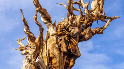
Stop 7: Ancient Bristlecone Pine Forest
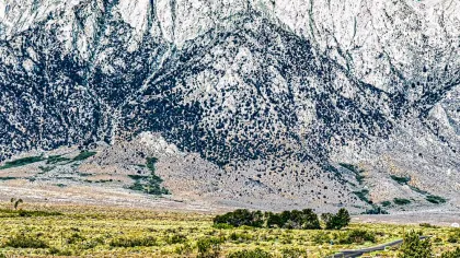
Depart U.S. 395 and head east into the White-Inyo Mountains, home to the world’s oldest trees, the ancient bristlecone pines. These photogenic icons with twisted trunks, contorted limbs, and bushy needles grow on the White-Inyo’s lofty slopes, an arid range that parallels the wetter Sierra. A few of these remarkable trees have lived as long as 4,000 years. At the Schulman Grove Visitor Center, walk among the ancients on the 1-mile Discovery Trail or the 4-mile Methusaleh Trail.
Planning Resources
- Ancient Bristlecone Pine Forest – https://www.fs.usda.gov/recarea/inyo/recarea/?recid=70821
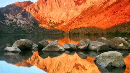
Stop 8: Convict Lake
Just 3 miles off U.S. 395, Convict Lake is one of the most photographed lakes in the eastern Sierra, and also one of the deepest—averaging 100 to 140 feet deep. But the lake’s biggest wow factor is its western backdrop: red and gray cliffs arrayed in a palette of stripes and swirls. They’re some of the oldest rocks in the Sierra Nevada Mountains. Photographers flock here to capture their kaleidoscopic colors—especially the rust, bronze, and gray “stripes” of 11,812-foot Laurel Mountain and the Sevehah Cliff. Take a 2.5-mile hike around the lakeshore, or rent a boat and cruise its cobalt waters. If you’re hungry afterward, the Aspen Grill at Convict Lake Resort serves fish tacos and burgers.
Planning Resources
- Convict Lake – https://www.monocounty.org/places-to-go/lakes-rivers-creeks/convict-lake/
Stop 9: Mammoth Lakes
In Mammoth Lakes, California’s largest ski resort morphs into a summer playground from June to September. Take the kids on the easy trail to Mammoth Consolidated Gold Mine and Heart Lake for a history lesson and a swim, or hike to 10,797-foot Duck Pass for an energetic climb to glacier-carved lakes and lofty views. Ride Mammoth Mountain’s gondola to 11,000 feet or pedal a mountain bike on 80 miles of single-track. At day’s end, choose your favorite IPA at Mammoth Lakes’ two breweries, Mammoth Brewery and Distant Brewing.
Planning Resources
- Mammoth Lakes Tourism – http://visitmammoth.com
- Things to Do While Visiting Mammoth Lakes – https://www.visitmammoth.com/things-to-do/
- Summer Activities in Mammoth Lakes – http://visitmammoth.com/things-to-do/summer-activities